MyGeodata Cloud is a complex portal for Geographic Information Systems (GIS) and CAD professionals, including both companies and enthusiastic individuals. Our Converter, Drive and Map services are designed to work together and support each other. We’re here to help you convert your GIS / CAD to various formats and coordinate systems, store and present it in one safe place. Ready to get started?
How it works
All MyGeodata Cloud services are web-based applications that work in most web browsers, but for the best user experience we recommend Google Chrome. You don’t need to download or install any software on your computer, just have to be connected to the internet. You don’t even need an account to start using our services because there is a free access to all applications with certain limits like amount of converted data or number of conversions per month.
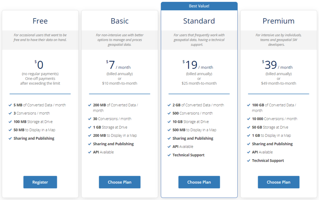
When you exceed the limits for a specific service (e.g. data conversion or transformation) you can pay for every single action by one-time payments but if you plan to use our services more often, we recommend you to create an account and choose one of our plans that suits you best concerning the planned number of conversions, the amount of data converted, the space required to store your data or the need of an API. See what plans we offer.
When you subscribe to a paid plan you will pay either monthly or annual recurring payments. But there is no long-term commitment and you can cancel your plan at any time.
User account
Although it’s not mandatory at first, we recommend you to register your user account to use our services. After free registration you will get some storage on Drive, the opportunity to share your data with other users or to view the history of your activities. No credit card is required to create an account. If you’d like to start using one of our plans, you will be prompted to create an account if you don’t already have one.
You can choose to register on MyGeodata Cloud with your email as an username and password or it’s possible to log in using third party accounts – Google or Facebook.
MyGeodata Converter
MyGeodata Converter is a web application designed for performing format conversions and transformations of spatial data coordinate systems. Both vector and raster GIS / CAD data are supported as well as most major formats and coordinate systems. You are able to upload and convert or transform your own geodata or can utilize data shared by other users in the MyGeodata Drive application. After uploading or selecting data, you can select the output data format, output coordinate system, and other parameters of the conversion. Finally you can download the result of the conversion in the form compressed file in ZIP format.
MyGeodata Drive
Another web application designed for browsing, storing or sharing spatial GIS / CAD data in the Internet environment is MyGeodata Drive. As a user you get allocated disk space, which you can use to upload both vector and raster spatial data. After uploading the data, metadata is automatically detected and registered. You can then edit some metadata, enter keywords, assign a license or a detailed description to the dataset. Your data can then be shared within the MyGeodata Drive with specific users or published publicly, in which case such a dataset will be included in search results for other MyGeodata Drive users. On the Drive, you can search for various data by entering keywords that are contained in its title or metadata. It is also possible to apply a filter according to the geographical area of interest or according to the type of data (point, line, polygon, raster). Of course, you can also sort the data on the Drive according to various criteria. For vector data, it is possible to display an attribute table with values or to display the data on a map. Finally, you can download selected datasets in the original format or convert them to other data formats or coordinate systems.
MyGeodata Map
MyGeodata Map is a simple map viewer where you can visualize spatial data stored on MyGeodata Drive. Just a basic and easy to use tool that lets you to overview selected geodata, without ability to work with styles.
Data security
All data transfers are performed using the encrypted SSL protocol, which ensures secure data transfer. The uploaded data is temporarily stored in the data center storage closest the user’s location and is further processed according to the user’s request. The result is also temporarily stored in the data center. After some time, the data is automatically deleted (unless the user chooses to keep it in storage within the account). Throughout the data is not accessible to anyone except the user (unless the user provides a download link to someone else), or GeoCzech, Inc. technical support, if requested by the user.
Technical support
We provide technical support for the users with Standard and Premium plan if they get into trouble working with any service within the MyGeodata Cloud.
But we greatly appreciate the feedback from all users (even without a plan). You can use technical support form (Contact us link) whenever you would like to let us know something.